テーマは「地図」にみる「世界観の移り変わり」。ユーラシアの様々な地域、時代の地図から、人々が世界をどのようにとらえていたかを探ります。当館所蔵の自鑪庁至烏斯蔵程站輿図も収録。
目次
図版編
第一部 天地の記録
第二部 東アジアの古地図 ―旧江上波夫コレクションから―
解説編
地図による「生活」と「世界」の表現
———–梅村坦
17-18世紀在華イエズス会士の世界図及び中国図に見る尺寸法
———江場山起
『自鑪廳至烏斯蔵程站輿圖』の新展開
———片山章雄
『自鑪廳至烏斯蔵程站輿圖』の知識背景と記載情報
———立石謙次
「清代乾隆期科布多疆図」について
———小沼孝博
遊牧世界と地図 ―江上波夫旧蔵資料から―
———–畠山禎
主要参考文献
Contents
Plates
I. Heavens and Earth Recorded
II. Ancient Maps of East Asia: From the Former Egami Collection
Essays
Mapping Lives, Mapping Worlds
—UMEMURA Hiroshi
Changes of Measurement Seen in the Chinese World Maps and Atlases of China Made by the Jesuits in China in the 17th and 18th Centuries
——–EBA Yamaki
Newly Discovered Aspects of the Map of the Routes from Luting to Tibet
—-KATAYAMA Akio
Knowledge behind the Production of the Map of the Routes from Luting to Tibet and Its Value as the Document
—–TATEISHI Kenji
Khobdo Frontier Map in Qinlong Era of the Qing Dynasty
—-ONUMA Takahiro
Nomads and Maps: From the Former Egami Collection
—HATAKEYAMA Tei
Selected Bibliography
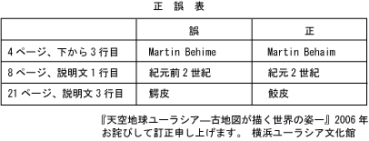
正誤表